Route measurement on public roads
The ADMA system is increasingly used for route measurement on public roads. The ADMA high-precision gyro measurement system fuses inertial data (acceleration and rotation rates) with GNSS to compute improved orientation and position. ADMA enables precise georeferencing of data, even in the presence of GNSS interference and outages.
GeneSys solutions
To ensure that the required accuracies are achieved, we have developed the ADMA-PP post-processing software. With ADMA-PP the recorded ADMA data can be optimized and GNSS correction data can be added afterwards.
- Users benefit from more than 25 years of application know-how and the experience of GeneSys experts

Recommended products

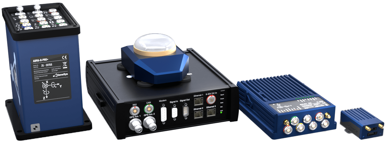
Our premium-star: ADMA-G PRO+
Complies with all international test standards EURO NCAP & NHTSA
Fiber-optic gyro system with three fiber-optic rotation rate sensors and three servo acceleration sensors class 1mg
Provides high-precision data even in the case of strong GNSS interferences
Validation of simulation models, ADAS Evaluation e.g. ACC, FCW, AEB (VRU, Car2Car), LSS (LDW, LKA) Chassis tuning
Options, Add-ons and accessories

NTRIP-DGNSS-Box 5
DGNSS-Korrekturdaten für hochpräzise Positionierung von einem RTK-Netzwerk-Provider oder von der GPS-Basistation
DGNSS Correction Data for High-Precision Positioning from RTK Network Provider or GPS Base Station
With the NTRIP-DGNSS-Box 5, an ADMA equipped with RTK capabilities can obtain positional correction data through the Network RTK (like SAPOS and ASCOS, SmartNet, …), without the need for a nearby Base Station. By receiving correction messages through the RTK network, this solution provides significant benefits when conducting tests over long distances, varying elevations, or areas with topographical obstacles that may obstruct communication with the Base Station.
Features
Scope of delivery

Option RTK2: High-precision position measurement using correction data
RTK stands for Real-Time Kinematic and is a technique based on carrier-based distance measurement that can RTK stands for Real-Time Kinematic and is a technique based on carrier-based distance measurement that can determine positions with high precision.
The method is much more accurate than code-based location. The basic concept is to eliminate the various error sources of raw GNSS positioning by using a local base station whose exact position is known. For this purpose, correction data of a virtual base station of different correction data services can be requested, or a local base station with its own GNSS receiver is used.
Product-Page
Option Multi-GNSS: Use of multiple satellite systems such as GPS, GLONASS, Galileo, Beidou
Today’s GNSS-Receivers have the option of accessing multiple satellite systems such as GPS, GLONASS, Galileo and Beidou.
By using these systems in addition to GPS the Receiver is able to track more Satellites which results in the following advantages:
Reduced signal acquisition time.
Improved position and timing accuracy.
Reduction of problems caused by obstacles such as buildings and leaves
Improved spatial distribution of visible satellites, resulting in improved position accuracy.

Option Dual-Ant: Two GNSS antennas option
Heading-Winkel Erkennung fĂĽr Stillstand und langsame Geschwindigkeiten
The Dual-Ant option provides heading angle detection without initialization and control at very slow speeds.
Among other things, this option is helpful when using robotic systems where a valid heading angle is needed right at the beginning.
Note: Only available in combination with RTK2 activation and dual antenna capable GNSS receiver

Post-Processing Software ADMA-PP
Merges ADMA inertial data, GNSS data and external additional information
Much higher position accuracy in general and eliminates jumps in position during partial or total GNSS shading (e.g. on emergence from a tunnel)
RTK correction data can be fed in without interruption
Additional features: Moving Base Add-On / Delta multi Add-On
Improved flexibility and accuracy by combining the forward / backward navigation solution
Save time: Retroactively change the ADMA configuration and fewer initialization steps
Track analysis, Road mapping, GIS data acquisition, Precise altitude profiling, Power train optimization, Consumption optimization, Verification of simulation models, Underground and tunnel survey

Mounting accessories
For all ADMA systems, various accessories are available for installation in the test vehicle
Seat rail adapter with ADMA mounting plate
Installation support for ADMA plus data acquisition systems with a quick-installation mounting pole or on-seat adapter
Mounting plate with quick-installation mounting pole
RT-Strut with ADMA mounting bracket

Option GNSS-Raw Data: Raw data output via Ethernet for post-processing
The GNSS-Raw Data option, like all of our feature enhancements, can be easily activated later without changing the hardware.
With the option you get access to the recorded GNSS raw data via the Ethernet interface and can significantly increase the GNSS accuracy in post-processing applications e.g. with our Post-Processing Software ADMA-PP.
Data logging is user-friendly with the free GeneSys Ethernet Logger software.
The GNSS Raw Data option is available for all ADMA models
Note: Separate WLAN router and Ethernet cable are required

Option DGNSS Correction Data: Correction data reception via Ethernet
Ideal on public roads
The option provides the capability to receive DGNSS correction data forwarded from a second ADMA
via WiFi / Ethernet.
This is the preferred option for multi-vehicle applications, e.g. LSS, ACC-, AEB- und FCW testing.
This option is used in place of radio modems, increasing the availability of DGNSS correction data, especially on public roads.