Software Versions
| SYSTEM / SOFTWARE | FIRST USABLE VERSION |
|---|---|
| ADMA Firmware | 30.8.1.8 |
| GNSS-Receiver Firmware | OEM70504 or OEM60730 |
| ADMA-PP | v1.10.x.y |
| Moving Base | v1.14 |
| Ethernet Logger | v1.17.x.y |
Data Input
In order to use Moving Base for calculating offline DELTA data, the following input data have to be recorded:
ADMA Ethernet Logger BIN (100 Hz)
Required Files:
• Ethernet Logger Binary Data file of ADMAnet dataformat v3.3.3 (.gsdb) • Ethernet Logger GNSS Raw data file (.gps)
• ADMA Configuration file (*.gsci)
Data Output
Moving Base calculated output data are compatible with the online Addon DELTA data. On top of the DELTA data there are output additional Moving Base data packets.
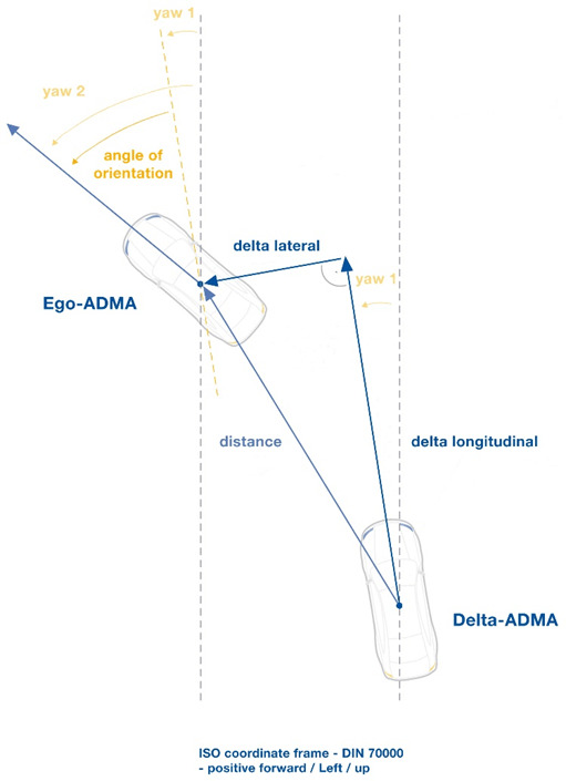
Moving Base calculates the distance between two moving vehicles. The measurement reference point is in the coordinate system of the DELTA-ADMA vehicle (Hunter vehicle). In this coordinate system, the Longitudinal direction (x direction) of the DELTA-ADMA is the INS-Angle-YAW. All data is defined in terms of ISO coordinate system, in reference to the configured POI. The data output rate at of the DELTA data is fixed to 100Hz.

Point of Calculation
Moving Base calculates the delta values between the defined POI at the Ego-ADMA and POI at the DELTA-ADMA. This allows to compare the DELTA data directly with the VUT (Vehicle under Test) sensor measurements.

Data Packets
Target Position
This data packet contains the position data of the Target vehicle in decimal degrees.
MovingBASE Target Longitude:
| NAME | UNIT | DESCRIPTION |
|---|---|---|
| Target_Longitude | ° | Target Longitude |
MovingBASE Target Latitude:
| NAME | UNIT | DESCRIPTION |
|---|---|---|
| Target_Latitude | ° | Target Latitude |
Version
This data packet contains the code version.
MovingBASE Version:
| NAME | UNIT | DESCRIPTION |
|---|---|---|
| Code_version | Version of Moving Base Calculator (X.Y.Z -MAJOR.MINOR.PATCH) |
Moving Base Longitudinal
This data packet contains the Moving Base position and velocity information, longitudinal.
MovingBASE Longitude:
| NAME | UNIT | DESCRIPTION |
|---|---|---|
| Long_Delta_Distance | m | Longitudinal distance |
| Long_Delta_Velocity | m/sec | Longitudinal difference velocity |
Moving Base Lateral
This data packet contains the Moving Base position and velocity information, lateral.
Delta Lateral:
| NAME | UNIT | DESCRIPTION |
|---|---|---|
| Lat_Delta_Distance | m | Lateral distance, Positive left |
| Lat_Delta_Velocity | m/sec | Lateral difference velocity, Positive left |
Moving Base Resultant 2D
This data packet contains the resultant Moving Base position and velocity information.
MovingBASE Resultant:
| NAME | UNIT | DESCRIPTION |
|---|---|---|
| Resultant_Distance | m | Resultant distance 2D (Latitude and Longitude) |
| Resultant_Velocity | m/sec | Resultant velocity |
Moving Base Angle
This data packet contains the angle information of the target in view of the hunter.
MovingBASE Angle:
| NAME | UNIT | DESCRIPTION |
|---|---|---|
| Angle_of_Orientation | ° | Angle of target in view of the hunter. Positive anti clockwise. Hunter Yaw (NED) – Target Yaw (NED) +/- 180 deg |
Moving Base Time and Forward Velocity
This data packet contains the Moving Base time and forward velocity information.
MovingBASE Time ForwardVel:
| NAME | UNIT | DESCRIPTION |
|---|---|---|
| Delta_Time | msec | Time stamp of Synchronized DELTA data. (GNSS time, milliseconds from midnight) |
| Target_Forward_Velocity | m/sec | Target forward velocity |
| Hunter_Forward_Velocity | m/sec | Hunter forward velocity |
Moving Base Forward Acceleration and Lateral Velocity
This data packet contains the forward acceleration and lateral velocity information of the target and hunter vehicle.
MovingBASE ForwardAccel and Lat Vel:
| NAME | UNIT | DESCRIPTION |
|---|---|---|
| Target_Forward_Acceleration | m/s² | Target forward acceleration |
| Hunter_Forward_Acceleration | m/s² | Hunter forward acceleration |
| Target_Lateral_Velocity | m/s | Target lateral velocity |
| Hunter_Lateral_Velocity | m/s | Hunter lateral velocity |
Lateral Acceleration and Pitch Angle
This data packet contains the lateral acceleration and pitch angle information of the target and hunter vehicle.
MovingBASE Lat Accel and Pitch Angle:
| NAME | UNIT | DESCRIPTION |
|---|---|---|
| Target_Lateral_Acceleration | m/s² | Target lateral acceleration |
| Hunter_Lateral_Acceleration | m/s² | Hunter lateral acceleration |
| Target_Pitch_Angle | ° | Target pitch angle (ISO positive in braking) |
| Hunter_Pitch_Angle | ° | Hunter pitch angle (ISO positive in braking) |
GPS Mode of Target and Hunter Vehicle
This data packet contains the GNSS mode of the target and hunter vehicle.
MovingBASE GPS Mode:
| NAME | UNIT | DESCRIPTION |
|---|---|---|
| Target_GPS_Mode | Coded status information of the Hunter ADMA. 0=error 1=Gyro not initialised 2=Waiting for Initialisation (not exceeded threshold speed for heading) 3=Not real time mode 5=accuracy worse than 10 6=accuracy 2m to 10m 7=accuracy 0.5m to 2m 8=accuracy 0.1m to 0.5m 9=accuracy better than 0.1m | |
| Hunter_GPS_Mode | Coded status information of the Hunter ADMA. 0=error 1=Gyro not initialised 2=Waiting for Initialisation (not exceeded threshold speed for heading) 3=Not real time mode 5=accuracy worse than 10 6=accuracy 2m to 10m 7=accuracy 0.5m to 2m 8=accuracy 0.1m to 0.5m 9=accuracy better than 0.1m |
Height
This data packet contains the resultant distance in height between target and hunter.
MovingBASE Height:
| NAME | UNIT | DESCRIPTION |
|---|---|---|
| Height_Delta_Distance | m | Resultant distance in height |
Resultant Distance 3D
This data packet contains the resultant distance 3D between Target and Hunter.
MovingBASE Resultant 3D:
| NAME | UNIT | DESCRIPTION |
|---|---|---|
| Resultant_Distance_3D | m | Resultant distance 3D (Latitude, Longitude and Height) |
EPE – Expected Position Error
This data packet contains the Moving Base expected error of position.
MovingBASE EPE:
| NAME | UNIT | DESCRIPTION |
|---|---|---|
| Stddev_Long_Delta_Distance | m | Standard deviation in Longitude |
| Stddev_Lat_Delta_Distance | m | Standard deviation in Latitude |
| Stddev_Height_Delta_Distance | m | Standard deviation in Height |
| Stddev_Resultant_Distance | m | Standard deviation 2D (sum vector of stddev Latitude and stddev longitude) |
Moving Base GNSS Raw
This data packet contains the raw GNSS Baseline information between the GNSS Antennas.
MovingBASE GNSS RAW:
| NAME | UNIT | DESCRIPTION |
|---|---|---|
| GNSS_Baseline_Lat | m | GNSS raw distance in Latitude |
| GNSS_Baseline_Long | m | GNSS raw distance in Longitude |
| GNSS_Baseline_Height | m | GNSS raw distance in Height |
| GNSS_Baseline_Distance | m | GNSS raw distance 3D (Latitude, Longitude and Height) |
Moving Base Hunter Position
This data packet contains the position data of the Hunter vehicle in decimal degrees calculated by the Moving Base.
MovingBASE Hunter Longitude:
| NAME | UNIT | DESCRIPTION |
|---|---|---|
| Hunter_Longitude | m | Calculated by Moving Base |
MovingBASE Hunter Latitude:
| NAME | UNIT | DESCRIPTION |
|---|---|---|
| Hunter_Latitude | m | Calculated by Moving Base |
INS Time
This data packet contains INS time data (ADMA time). The time indication is UTC.
MovingBASE INS Time:
| NAME | UNIT | DESCRIPTION |
|---|---|---|
| INS_Time_msec | Msec | Time in Milliseconds, UTC |
| INS_Time_Week | Week | Weeks, Start 0h 6-Jan-1980 |
Moving Base Mode
This data packet contains the Moving Base Mode.
MovingBASE INS Time:
| NAME | UNIT | DESCRIPTION |
|---|---|---|
| MovingBase Mode | Coded status information of the Moving Base calculation. 1=no GNSS-Data 2=single GNSS 4=DGNSS coarse 8=RTK |


